Plan, verify, and deliver with survey-aligned aerial data
AEC DRONE MAPPING, MEASUREMENT & MONITORING
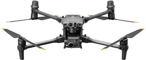
From design development through punch list, we give AEC teams clear visuals, reliable measurements, and shareable documentation. Using the DJI Matrice 4-Series platform, we produce thermal imagery, high-resolution media, orthomosaics, 3D surfaces/point clouds, and volume reports—so you can coordinate faster, catch issues earlier, and keep stakeholders aligned.
Why AEC Teams Choose DRONE FIDELITY®
- Coordination & Planning: Up-to-date site context for design reviews, logistics, laydown, and sequencing
- Quantities & Volumetrics: Stockpile measurement and cut/fill tracking with CSV tables
- Mapping & Modeling: Scalable 2D orthomosaics, DSMs, and 3D point clouds for the full site
- Documentation: Date-stamped progress, milestone capture, RFI/CO support, and dispute resolution
- Thermal Options: Roof/Solar checks, moisture/heat signatures, and envelope screening
Who It’s For
- Architects & BIM/VDC: site models, context imagery, façade and roof references
- Civil/Structural MEP Engineers: plan overlays, grading checks, and change detection
- GCs/CMs & Site Supervisors: progress verification, logistics, and safety snapshots
- Owners/Developers: visual proof of performance and stakeholder-ready updates
- Surveyors & Consultants: supplemental imagery and models for field efficiency
Deliverables & Formats
- High-resolution aerial photos and 4K video (marketing and technical angles)
- 2D orthomosaics (GeoTIFF, KMZ) with distance/area tools
- DSM/DTM as needed; contours and cut/fill summaries
- 3D point clouds/surfaces (LAS/LAZ, PLY), meshes (OBJ)
- Volumetrics (CSV tables) and annotated PDFs
- Shareable viewer links for easy stakeholder access
- Thermal imagery (roof/solar, envelope screening) with findings pages
Accuracy & Quality Assurance
- Acquisition: RTK on every flight; optional GCPs with independent checkpoints
- QC: camera calibration, overlap checks, reprojection error review, ground truth spot checks
- Precision Statements: Relative accuracy is typically within centimeters on-site; absolute accuracy depends on GCP density, site conditions, and specifications — we document assumptions and results in each report
- Surveying Scope: We support licensed surveyors and engineers; deliverables are not a sealed survey
AEC Workflow
- 1) Kickoff: scope, required formats/units, coordinate system, deliverable dates
- 2) Flight Plan: geometry, altitude, overlap, RTK source, safety plan/JSA
- 3) Acquisition: RTK capture; optional GCP/checkpoints
- 4) Processing: photogrammetry/thermal; QA review; change detection as specified
- 5) Reporting: PDF summary (assumptions, accuracy notes), CSV tables, viewer link
- 6) Cadence: weekly/biweekly/milestone flights for trending and variance tracking
Compliance & Site Safety
- FAA Part 107 remote pilot in command; insured operations
- Site orientation/JSA, radio coordination, spotter usage as needed
- Procedures for cranes, personnel, traffic, and controlled airspace
- Data handling and secure file delivery per client requirements
AEC FAQs

- How often can you fly?Weekly, biweekly, or milestone-based – set the cadence that fits your schedule. Scheduling details
- Do you use RTK and GCPs?Yes – RTK on every flight; GCPs/checkpoints added per accuracy requirements. See RTK/GCP FAQ
- Can you measure stockpiles?Yes. We provide volume tables (CSV), annotated maps, and cut/fill summaries. Recurring site monitoring
- Which formats do you deliver?GeoTIFF/KMZ, LAS/LAZ, OBJ/PLY, DXF/DWG overlays (as applicable), CSV, PDF, and a shareable viewer link. Deliverables · Delivery method
- Do you replace a licensed survey?No. We support surveyors and engineers. For sealed documents, engage a licensed professional. Surveying policy
- Do you offer thermal?Yes – roof/solar and envelope screening with findings included in the report. Thermal imaging FAQ
- Where do you operate?Washington Metropolitan Area; regional travel available for longer engagements. Service area details
Book AEC Mapping & Monitoring
Reduce rework, align stakeholders, and keep your project on schedule with survey-aligned aerial data.