Reliable Aerial Inspections of Critical Infrastructure
TOWERS, BRIDGES & SOLAR INFRASTRUCTURE
DRONE FIDELITY® delivers high-resolution imaging, orthomosaics, 3D models, and thermal data to help infrastructure teams monitor, maintain, and document assets without placing workers at risk. AI-assisted analysis helps you identify issues faster and inspect more frequently at scale.
What We Inspect
- Cell & Communication Towers: detailed photos of mounts, antennas, cabling, and hardware
- Bridges & Overpasses: visual/thermal checks for cracks, corrosion, spalling, and surface defects
- Solar Farms: panel damage, faulty strings, and overheating via thermal sensors
- Power Lines & Utility Structures: poles, transformers, insulators, and related equipment
Why Choose Us?
- Zero Climbing Required: eliminate safety hazards and reduce downtime
- Multi-Mode Inspections: visible, thermal, and AI-enhanced analysis in a single flight
- Detailed Visual Reports: PDFs with images, annotations, and prioritized findings
- Precision Mapping: 2D orthomosaics and 3D point clouds with GPS-tagged accuracy
What’s Included
- High-resolution aerial photos and 4K video
- Thermal imaging for heat detection and system diagnostics
- Optional 2D orthomosaics and 3D point cloud exports
- PDF report with annotations and flagged findings (on request)
- Quick digital delivery via secure download link
Infrastructure Services FAQs
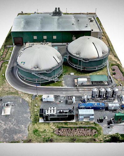
Industrial Renewable Energy Infrastructure
Infrastructure & Asset Inspection 3D model in 4K (UHD)
DRONE FIDELITY® | dronefidelity.com | 415-999-9994
- Service area?
Washington Metropolitan Area; regional travel considered case-by-case. Service area · Travel fees - How close can you get?
Close-range RGB/thermal with standoff distances per site safety and airspace requirements; we coordinate with site owners. Flight regulations · Safety protocols - Safety & compliance?
FAA Part 107, job-site briefings, and documented flight logs; permits and escorts arranged as needed. Insurance coverage · On-site safety - What deliverables?
High-resolution obliques, detail imagery, optional orthos/models for context, and a concise PDF report. Deliverables · Delivery method - Turnaround?
Typically 2–3 business days after acquisition; rush available depending on scope and weather. Turnaround · Project cost
Inspect Critical Infrastructure the Smarter Way
Aerial inspections deliver high-resolution, thermal, and 3D outputs for bridges, towers, solar farms, and power lines – all while keeping ground crews safe.